
The Kano erosion flood intervention project is gaining momentum as the Kano State Government intensifies efforts to address severe environmental degradation affecting several communities. The initiative focuses on controlling erosion, reducing flood risks, and improving safety in vulnerable areas across the state.
The Kano erosion flood intervention project is being implemented in response to long-standing environmental challenges that have resulted in displacement, infrastructure damage, and loss of lives in parts of the state.

Government Reaffirms Commitment to Environmental Protection
The Kano State Government has reiterated its commitment to tackling erosion, flooding, and other environmental threats affecting residents.
Officials say the intervention is part of a broader environmental management strategy aimed at protecting lives and restoring degraded land areas.
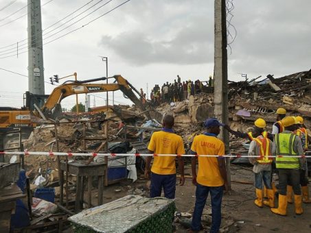
Inspection Visit to Bulbula Gayawa Site
The Commissioner for Water Resources, Environment and Climate Change, Dr. Dahiru Muhammad Hashim, inspected ongoing work at the Bulbula Gayawa erosion site.
Key points from the visit include:
- Review of ongoing construction progress
- Assessment of environmental impact control measures
- Evaluation of community safety conditions
- Monitoring of flood prevention infrastructure
The site spans Nasarawa and Ungogo Local Government Areas and remains one of the most affected erosion zones in the state.
World Environment Day Connection
The inspection formed part of activities marking World Environment Day, observed globally on June 5.
The visit also served as an opportunity to assess progress on long-term environmental rehabilitation projects.
Bulbula Gayawa Erosion Site Under Major Rehabilitation
The Bulbula Gayawa area is one of the most severely affected erosion zones in Kano State.
Authorities describe it as a critical site requiring extensive engineering work due to its size and long-term degradation.
Scale of Environmental Damage
The erosion channel stretches over four kilometres and has expanded significantly over the years.
Officials report that:
- Erosion channels increased from 2 to 13 over time
- The site affects multiple surrounding communities
- Flooding has repeatedly disrupted movement and livelihoods
- Some incidents have resulted in loss of lives, including children
Environmental and Social Risks
The Kano erosion flood intervention project is designed to address multiple risks, including:
- Flood-related displacement
- Destruction of roads and housing infrastructure
- Public health risks linked to stagnant water
- Safety concerns in densely populated communities
Engineering Works and Infrastructure Development
The ongoing project includes major drainage construction and bridge development aimed at controlling water flow and stabilizing the environment.
Drainage Channel Expansion
According to project officials, the erosion channel measures between 10 and 16 metres in width and extends approximately 2.8 kilometres toward River Jakara.
This drainage system is designed to manage water flow from key urban areas, including:
- GRA Kano
- Nasarawa district
- Tarauni area

Bridge Construction and Structural Work
The project includes multiple infrastructure components:
- Construction of five new bridges
- Retention of three existing structurally sound bridges
- Demolition and reconstruction of one bridge at Gada
- Reinforced drainage structures across erosion pathways
These structures are intended to improve connectivity and reduce flood-related disruptions.
Safety Concerns and Community Awareness
Officials have raised concerns about safety risks associated with construction zones and improper waste disposal practices.
Warning Against Waste Dumping
Authorities have warned residents against dumping waste into drainage systems.
Such practices can:
- Block water channels
- Increase flooding risks
- Damage infrastructure
- Undermine long-term project sustainability
Public Safety Measures
Safety measures implemented at the site include:
- Installation of warning signs
- Community sensitisation campaigns
- Restricted access to construction zones
- Monitoring of high-risk areas
Residents, especially children, have been urged to stay away from active construction sites.
Project Timeline and Progress Updates
Officials report steady progress on the project despite earlier concerns about its complexity and scale.
Expansion of Project Scope
The project scope increased significantly after erosion channels expanded from five to thirteen, requiring redesign and additional engineering work.
This adjustment led to:
- Revised construction timelines
- Expanded infrastructure requirements
- Increased engineering complexity
- Additional technical assessments
Expected Completion Timeline
Despite challenges, authorities remain confident that the project will be completed within the next year.
They emphasize that quality control measures are being strictly enforced throughout construction.
Community Impact and Local Feedback
Residents of affected communities have expressed cautious optimism as work progresses.
Reduced Security Concerns
Local leaders report that the construction activity has contributed to improved safety in the area.
Before intervention, parts of the erosion site were reportedly used for criminal activity due to its abandoned and hazardous condition.
Public Health and Safety Improvements
Residents also highlight previous incidents involving flooding and erosion-related accidents.
The ongoing project is expected to:
- Reduce flood-related hazards
- Improve environmental sanitation
- Enhance mobility and infrastructure access
- Strengthen community resilience
Technical Oversight and Quality Control
Project implementation involves strict engineering supervision and collaboration with academic institutions.
Collaboration with Experts
The project team works closely with specialists, including experts from Bayero University Kano, to ensure technical accuracy and safety standards.
Quality Assurance Measures
Quality control includes:
- Regular material testing
- Structural integrity assessments
- Engineering compliance checks
- Continuous site monitoring

FAQ
What is the Kano erosion flood intervention project?
It is a government initiative aimed at controlling erosion, reducing flooding, and improving environmental safety in affected communities in Kano State.
Where is the main erosion site located?
The primary site is the Bulbula Gayawa area, which spans Nasarawa and Ungogo Local Government Areas.
What infrastructure is being built under the project?
The project includes drainage channels, bridges, and reinforced erosion control structures to manage water flow and prevent flooding.
How will the project affect local communities?
It is expected to improve safety, reduce flooding risks, restore damaged infrastructure, and enhance environmental conditions.
Conclusion
The Kano erosion flood intervention project represents a major effort by the state government to address long-standing environmental challenges. With large-scale drainage systems, bridge construction, and community safety measures underway, the project aims to reduce flooding risks and restore stability to affected areas. As work continues, authorities maintain that the initiative will deliver long-term environmental and social benefits to residents.
Click here for more news