
Chinese underwater drone Indonesia Lombok Strait discovery has drawn international attention after a fisherman recovered a suspected surveillance device from one of the world’s most strategic maritime routes.
The unexpected find highlights growing concerns over underwater reconnaissance activities and the increasing importance of ocean data in modern military strategy.
Discovery of Chinese Drone in Indonesian Waters
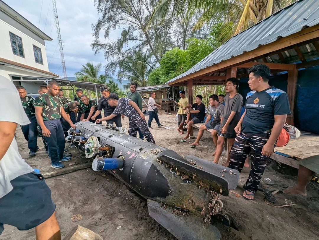
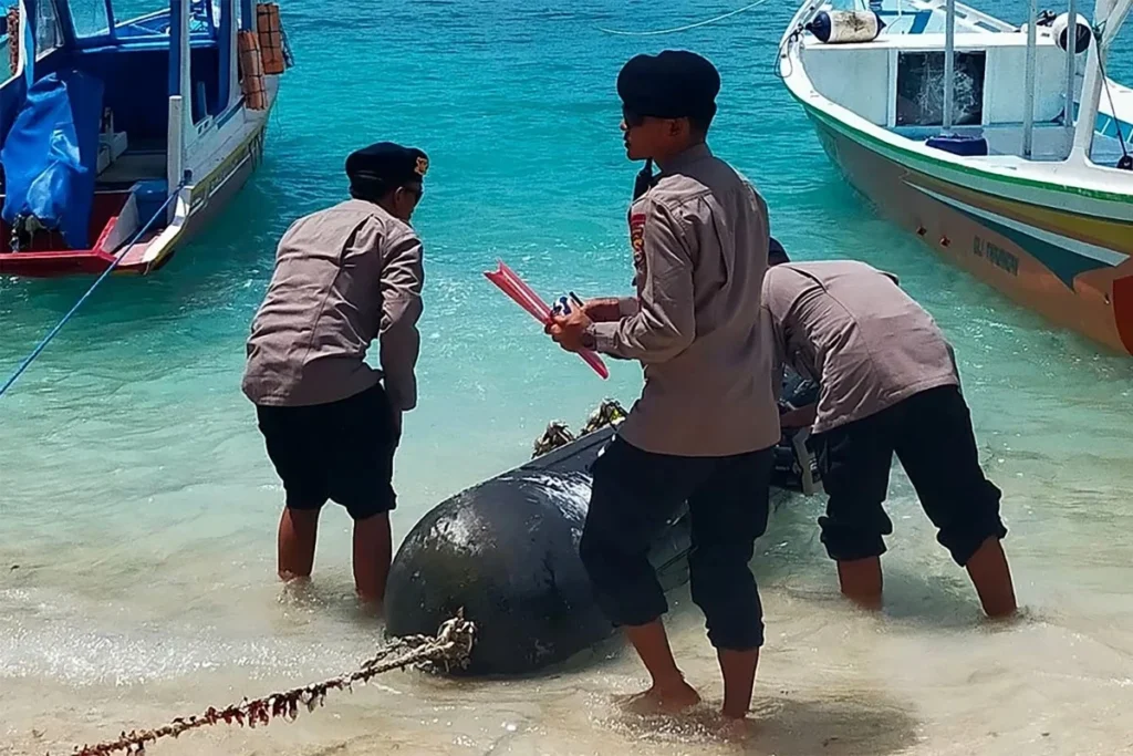
Chinese underwater drone Indonesia Lombok Strait incident began when a local fisherman retrieved an unusual device from the sea. The object was later identified as a Chinese-made underwater drone developed by the China Shipbuilding Industry Corporation.
Authorities quickly secured the device and transported it to a military facility in Indonesia for further examination.
Immediate Military Response
The recovered drone was handed over to Indonesian military personnel and taken to a base in Mataram.
Initial inspections revealed:
- No explosives onboard
- Presence of advanced surveillance equipment
- Components designed for oceanographic data collection
This confirmed that the drone was not intended as a weapon, but rather as a reconnaissance and research tool.
Technical Features of the Drone
Investigators reported that the drone contained:
- Hydroacoustic sensors
- Seabed mapping instruments
- Internal compartments for scientific equipment
The device also featured a hatch and complex cable systems, suggesting it was built for long-duration underwater missions.
Strategic Importance of the Lombok Strait
Chinese underwater drone Indonesia Lombok Strait case is significant due to the location where the device was found. The Lombok Strait is one of the most critical shipping lanes in Southeast Asia.
Key Global Shipping Route
The strait serves as a vital connection between the:
- Pacific Ocean
- Indian Ocean
It is widely used by:
- Supertankers
- Bulk carriers transporting coal and ore
- Large commercial vessels
Because of its depth and navigability, the Lombok Strait is often preferred over other regional routes for large ships.
Strategic Military Relevance
Beyond commercial importance, the strait also holds military value. Control and monitoring of such waterways can influence:
- Naval movement
- Trade security
- Regional power balance
This makes any surveillance activity in the area particularly sensitive.
Possible Purpose of the Underwater Drone
Chinese underwater drone Indonesia Lombok Strait discovery has raised questions about the intended mission of the device.
Seabed Mapping and Surveillance
Experts suggest the drone was likely used for:
- Mapping underwater terrain
- Monitoring shipping traffic
- Collecting environmental data
Such information can be used for both civilian and military purposes.
Dual-Use Technology Concerns
Although officially described as research tools, underwater drones can have dual-use applications. Data collected from these devices can help:
- Improve submarine navigation
- Enhance stealth capabilities
- Identify strategic underwater routes
This has led to increased scrutiny of similar activities worldwide.
China’s Expanding Ocean Research Operations
Chinese underwater drone Indonesia Lombok Strait incident fits into a broader pattern of global maritime research activities conducted by China.
Global Deployment of Research Vessels
Chinese vessels have reportedly operated in multiple strategic regions, including:
- Areas near Guam
- Waters around Hawaii
- Regions close to Taiwan
These missions often involve extensive data collection on ocean conditions.
Role of Scientific Institutions
Organizations such as the Ocean University of China have contributed to research involving underwater sensors and monitoring systems.
In recent years, tests have included deploying networks of deep-sea sensors capable of detecting underwater movement.

Military Implications of Ocean Data Collection
Chinese underwater drone Indonesia Lombok Strait case underscores the growing importance of oceanographic data in defense planning.
Enhancing Submarine Capabilities
Seabed mapping allows submarines to:
- Navigate more efficiently
- Avoid underwater obstacles
- Reduce detection by enemy sonar
Understanding underwater terrain is crucial for modern naval operations.
Importance of Hydroacoustic Data
Hydroacoustic research helps determine how sound travels underwater. This knowledge is essential for:
- Detecting submarines
- Improving sonar systems
- Monitoring naval activity
Such capabilities are key components of maritime security strategies.
![]()
Regional and Global Security Concerns
Chinese underwater drone Indonesia Lombok Strait discovery has prompted wider discussions about maritime security and sovereignty.
Concerns for Southeast Asia
Countries in the region may view such incidents as potential threats to:
- Territorial waters
- Economic zones
- National security
This could lead to increased monitoring and stricter maritime regulations.
Broader Geopolitical Implications
Globally, the incident reflects:
- Rising competition in maritime domains
- Increased use of technology in intelligence gathering
- Growing overlap between civilian research and military strategy
These trends are shaping the future of naval operations and international relations.
FAQ
What is the Chinese underwater drone found in Indonesia?
The Chinese underwater drone Indonesia Lombok Strait device is a surveillance and research tool equipped with sensors for seabed mapping and ocean data collection.
Why is the Lombok Strait important?
The Lombok Strait is a major global shipping route connecting the Pacific and Indian Oceans, making it strategically significant for trade and military operations.
Was the drone dangerous?
No explosives were found on the drone, indicating it was designed for surveillance and research rather than direct attack.
How can underwater drones be used militarily?
They can collect data to improve submarine navigation, enhance stealth capabilities, and monitor maritime traffic.
Conclusion
Chinese underwater drone Indonesia Lombok Strait discovery highlights the increasing role of advanced technology in maritime surveillance and global security. While the device appears to have been used for research purposes, its potential military applications raise important questions about the balance between scientific exploration and strategic intelligence gathering. As nations continue to invest in ocean data capabilities, such incidents are likely to become more frequent, reinforcing the need for clear international frameworks and cooperation.
PLEASE CLICK HERE FOR MORE NEWS