
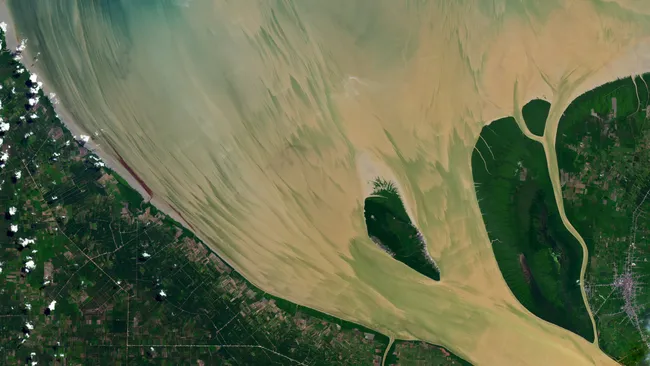
The Rokan River satellite image captured over Indonesia has revealed unusual and visually striking patterns formed by sediment movements influenced by strong tidal forces. The image, taken from space, shows how natural forces such as lunar-driven tides and river flow can combine to create intricate, brushstroke-like formations in coastal waters.
This rare visual phenomenon was observed at the mouth of the Rokan River in Sumatra, where river water meets the sea. The patterns became especially pronounced during a period of unusually high tides linked to a full “Strawberry Moon,” highlighting the connection between lunar cycles and Earth’s coastal systems.
Satellite Captures Rare River Sediment Patterns in Indonesia
The Rokan River satellite image offers a unique look at how natural processes shape Earth’s surface. The image was captured by the Landsat 8 satellite, operated through the Earth observation program of Landsat 8.
The photograph shows the river’s estuary where freshwater from the land mixes with saltwater from the ocean. Instead of uniform water, the surface appears painted with swirling, brushstroke-like streaks of sediment.
Key Details from the Observation
- Location: Rokan River estuary, Sumatra, Indonesia
- Coordinates: Near northern coast of Sumatra
- Date Captured: June 23, 2024
- Satellite: Landsat 8
- Phenomenon: High-tide-driven sediment dispersion
This Rokan River satellite image stands out because of its artistic visual patterns formed entirely by natural hydrodynamic processes.
Where the Rokan River Is Located
The Rokan River is a major waterway in Southeast Asia, flowing through Indonesia’s Sumatra island before emptying into the Strait of Malacca.
Geographic Overview of the River
Rokan River stretches approximately 350 kilometers from the Barisan Mountains in western Sumatra to the northern coastline.
Important Geographic Features
- Located on the island of Sumatra
- Empties into the Strait of Malacca
- Forms a brackish estuary influenced by tides
- Surrounds and flows around smaller islands such as Halang Island
Estuary Formation
At the river’s mouth, freshwater meets saltwater, creating a dynamic environment where sediment is constantly moved, suspended, and reshaped. This mixing zone is responsible for the visual complexity seen in the Rokan River satellite image.
How the Full Moon Influenced River Tides
One of the key drivers behind the unusual sediment patterns is the lunar cycle. During a full moon, gravitational forces between the Earth and the Moon become more aligned, leading to stronger tidal effects.

The Role of the Strawberry Moon
The event coincided with a full “Strawberry Moon,” a name traditionally given to the June full moon.
During this phase:
- The Sun, Earth, and Moon align more directly
- Gravitational pull on Earth’s oceans increases
- Tides become higher than average (spring tides)
These stronger tides contributed significantly to the sediment movement captured in the Rokan River satellite image.
Impact on River Sediments
High tides push seawater further inland while river currents push outward. This interaction:
- Suspends fine sediments in the water
- Creates swirling flow patterns
- Produces visible streaks from space
Why the Patterns Look Like Brushstrokes
The most visually striking aspect of the Rokan River satellite image is the resemblance of sediment streaks to painted brushstrokes. This is not artistic design but a natural result of fluid dynamics.
Physics Behind the Patterns
Several physical processes contribute to the formation:
- Turbulent mixing of freshwater and seawater
- Sediment suspension due to wave energy
- Variable flow speeds across the estuary
- Interaction between tidal currents and river discharge
These combined effects produce curved and elongated sediment trails that appear almost artistic when viewed from orbit.
Estuary Mixing Dynamics
In estuarine environments like the Rokan River:
- Saltwater is denser and moves differently than freshwater
- Layers of water can slide over one another
- Sediments are redistributed in complex ways
This creates the signature “painted” look visible in the Rokan River satellite image.
Role of Landsat 8 in Earth Observation
The ability to capture such detailed natural phenomena from space comes from decades of satellite Earth observation programs.
NASA and USGS Collaboration
The image was taken by Landsat 8, part of a long-running Earth observation mission operated by NASA and the U.S. Geological Survey.
Imaging Capabilities
Landsat 8 provides:
- High-resolution multispectral imaging
- Global coverage of land and coastal areas
- Regular revisit cycles for change detection
This makes it possible to monitor environmental changes like sediment flow in rivers such as the Rokan.
Importance of Satellite Data
The Rokan River satellite image demonstrates how satellites help scientists:
- Track coastal erosion
- Monitor river discharge
- Study sediment transport
- Understand climate-related changes in water systems
Why This River Image Matters for Science
Beyond its visual beauty, the Rokan River satellite image provides valuable scientific insight into coastal dynamics and environmental processes.
Environmental Monitoring Applications
Researchers use such imagery to:
- Study sediment behavior in estuaries
- Understand flood and tide interactions
- Analyze water quality and mixing zones
- Observe seasonal and lunar-driven changes
Climate and Coastal Studies
Satellite images like this also contribute to broader climate research by helping scientists:
- Track changes in sea level
- Monitor coastline shifts
- Understand ecosystem responses to tidal forces
The Science Behind Earth’s Natural Artwork
The Rokan River example shows how Earth’s processes can create visually stunning patterns when observed from space. While these formations may resemble human-made art, they are entirely natural and driven by physics.
The Rokan River satellite image continues to serve as a reminder of how dynamic and interconnected Earth’s systems are, especially in coastal regions where land, river, and ocean interact.
FAQ – Rokan River Satellite Image and Full Moon Effects
What causes the brushstroke patterns in the Rokan River satellite image?
The patterns are caused by sediment movement and mixing of freshwater and seawater influenced by strong tidal currents.
How did the full moon affect the river’s appearance?
The full moon created stronger-than-usual tides, which increased water movement and sediment suspension in the estuary.
Which satellite captured the Rokan River image?
The image was captured by Landsat 8, an Earth observation satellite operated by NASA and the USGS.
Where is the Rokan River located?
The river is located on the island of Sumatra in Indonesia and flows into the Strait of Malacca.
Conclusion
The Rokan River satellite image provides a fascinating glimpse into how lunar forces and natural water dynamics interact to shape Earth’s landscapes. What appears as abstract artwork from space is actually the result of complex environmental processes involving tides, sediment flow, and river-ocean mixing.
By combining satellite technology with Earth science, researchers continue to uncover detailed insights into how our planet’s waterways behave under changing natural conditions.
Click here for more news